eCard #113 – A < Lovely > Walk in the Khumbu
Readers may recall that my adventure to the Khumbu Valley of Nepal (eCard #105) with the goal of summiting two somewhat technical 6000m peaks (“The Khumbu Classics”) in April of this year was thwarted with some sort of respiratory issue, probably exacerbated by the altitude. I ended up descending from the base camp of Island Peak breathing from an oxygen cylinder. In addition to not reaching the summits of either Lobuche or Island Peak, many of the sub-goals of that trip were unattained – reaching Mt Everest base camp, climbing 5500m Kala Patthar to get views of Everest, and walking in the Khumbu icefall above base camp. Oh, well.
You may also recall at the end of that trip description I expressed little interest in returning, closing with, “Never say never, but I need some time to forget.”
During the summer, not really certain that it was just a health issue holding me back in Nepal (or at least feeling I needed to prove it to myself), I executed a rather busy plan geared toward rebuilding some confidence in the mountains – 4000m peaks in the Italian Alps, walking the Haute Route (with it’s many ups and downs), walking the hills of the Balkans, summiting the 7th highest peak in Europe (Tetnuldi in Georgia at 4900m) and finally trekking to and climbing Kang Yatse II (6150m) in the Indian Himalaya. Oh, and conquering the occasional pastry enroute.


I hadn’t confirmed the trip to India until the end of July – I waited to see how I fared in the Alps and the Haute Route. I still had a bit of trepidation as I hadn’t been above 4300m. But in India I would be climbing again with Rolfe who has become a cheerleader of sorts for my “Seven 7ths at 70 project”. And, lo and behold, India worked out great. I felt really strong all the way to the summit. OK!
Rolfe understood my dislike of leaving projects unfinished, and while in India we had talked about my returning to do the “Khumbu Classics”. Seeing me off at the airport in Leh, he said, “See you in Nepal in October!” …. I guess it took just 5 months to forget.
It’s a Small World, Part I
Our group of 21 (!!) were the first to the airport in Ramechhap, well before sunrise for our flight to Lukla – hoping to be in the front of the queue to get out. Amidst the crowd that eventually formed, I ran into Nema Sherpa from the India trip – the lead on my rope to the summit. He was doing a trip with another outfitter.
Also in the crowd was a real celebrity, though I didn’t go up to meet him. It was Kami Rita Sherpa who summited Mt. Everest for the record 28th time in May (his 27th ascent was one week earlier…). Makes you feel like a real slacker.


Trekking Day 1 – Lukla to Phakding
Arriving in Lukla, we had a late breakfast and then hit the trail. The first thing that I noticed was how many more people there were trekking this route in the fall than there were in the spring. It poured during the day and we mostly dried out by the time we arrived at the tea house in Phakding.

Warming up in the dining room that evening I ordered meat momos for dinner – a Tibetan/Nepali dumpling. When mine arrived I bit into one which had that taste you get when you bite into a wormy apple. It was not pleasant. I asked if anyone else had ordered the meat momos, and one of the trekkers said, “Yes. They’re lovely.”
Wait.
Stop.
Just stop right there.
Lovely? A momo?
My dictionary offers the following:
     lovely /lŭv′lē/
     adjective

     1. Beautiful especially in a pleasing or charming way, particularly reserved to describe young women.

     2. When used in sarcasm to describe something which is decidedly not lovely, and the only authorized use for the word when not referring to young women.
So, no item of food can be legitimately described as lovely. It just doesn’t work. Among many possible descriptors, a momo can be good, tasty, delicious, yummy, scrumpdillyicious, or, as in the case of the one I bit into, foul. But lovely?
No.
An illustrative example will help clarify this self-evident issue. Below are two photos. The photo on the left is of a Nepali/Tibetan momo. On the right is Japanese K-POP singer Momo of Twice.

Questions?
In writing, voice inflections which make sarcasm easier to spot are difficult to ascertain. Adhering to the strict definition as indicated above, sarcastrophes should not be necessary, but to be crystal clear, one should write, for instance, “That Big MacTM was <lovely>” .
The comment over dinner that launched me on this came from a Brit. They are routinely overheard squealing about lovely cups of tea. It’s no wonder they lost their empire.
In a loosely related subject, there are a few idioms we use in English to describe dressing things up with varying levels of success. For instance, to “gild a lily” is to add unnecessary ornamentation to something already beautiful. It may also have the connotation of ruining the object in the process. (Apparently, the origin of this is a misquote from Shakespeare’s “King John” who described the unnecessary acts of gilding refined gold, painting lilies, perfuming a violet, or adding another hue to the rainbow.)
“Putting lipstick on a pig” means trying to dress something up that can’t be hidden. With or without lipstick, you still know it’s a pig. Archaic versions of this include, “A hog in a silk waist coat is still a hog,” and, “you can’t make a silk purse from a sow’s ear”. I don’t know why pigs have been held up as quintessentially ugly throughout human history. Piglets are kinda cute, though never lovely.

I have been searching for a good phrase to describe the process of beautifying something ugly and in the process making it worse. I’m thinking here of tattoos. The Germans have a compound word, verschlimmbesserung, which means roughly to worse-improve, maybe the English equivalent would be disimprovement. But we need a good idiom, preferably one that involves pigs. I’m open to ideas.
Back to the trek.
Trekking Days 2 through 8 – Namche to Thagnak
The walk to Namche (3440m) follows the Dudh Koshi (Milk River) – that drains the southern side of the Everest massif. You cross the river several times on suspension bridges with the final crossing on a high bridge and then climb 800m to arrive at the base of the town. Back in the spring, I ate up the hill and continued strong for the next week. This time, the hill was a struggle. I had no strength in my legs.

This condition carried on for the acclimatization hike above Namche to the Everest View Hotel the next day. The day after that we put Namche behind us as we headed toward Gokyo. There’s a long climb up to where we had lunch, and for the last hour I had to give my day pack to one of the guides. I couldn’t breathe and had no strength. I only managed to force down half of my lunch (only the rice), the rest being completely unappetizing.

The afternoon walk up to Dhole (4200m) was a struggle. The natural assumption was that I was suffering from acute mountain sickness (AMS) and was not acclimatizing to the altitude, but my blood oxygen saturation level (%SpO2) was 92% indicating that I was acclimatizing well (mine is 96% at sea level). (Another guy on the trip was suffering and got on horse back. His %SpO2 was 30%. 50% is horrible. He was evacuated by helicopter.)
The dining room at Dhole was like an oven. The heating stove (using dried yak dung as the fuel) was stoked up and the room was crowded with other people. At dinner I was sitting next to the stove, wearing my down parka with the hood up. I was shivering uncontrollably. We couldn’t figure out what was going on. I had a light case of diarrhea. I didn’t have a headache or nausea (signs of AMS), and hadn’t had symptoms all day. We finally surmised that I probably had a mild case of food poisoning, but from where? I started a 4 day course of Cipro.

The next day walking up to Machermo (4470m) was worse. I couldn’t eat at all, and it was a struggle to breathe. I was thinking of bailing out – I wasn’t having any fun. But I decided to go on the next day to Gokyo (4790m) where we would have a rest day and see how things went.
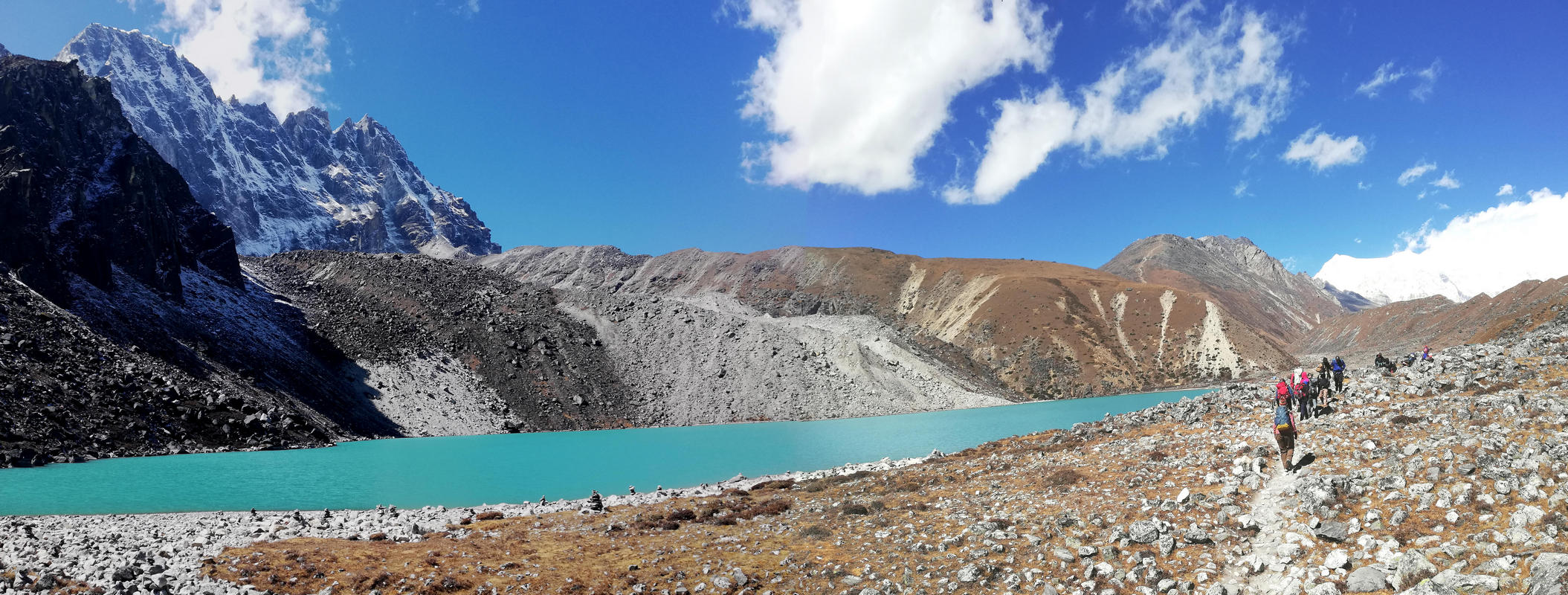
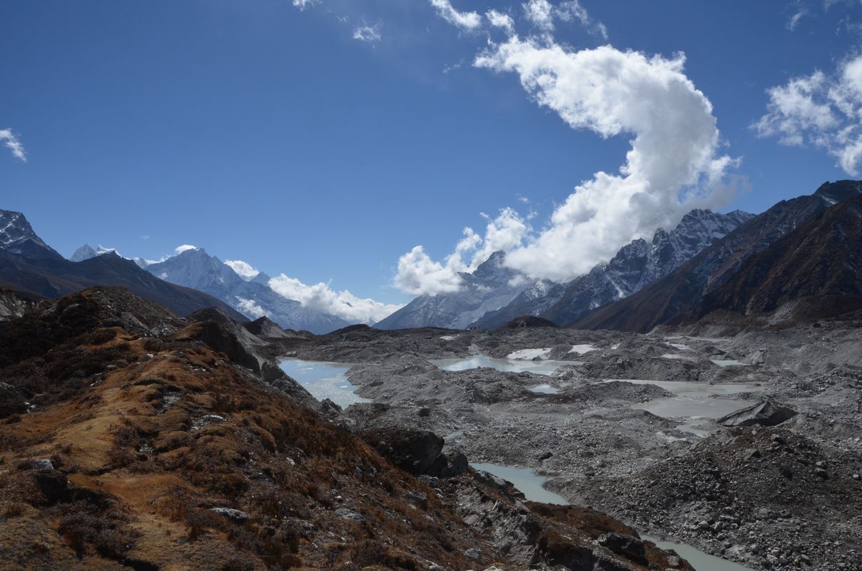
The walk up to Gokyo had some steep sections which were a grunt for me. In the spring it was clouded over and snowed in the afternoon, restricting our views. This time we had great views of 8188m Cho Oyu 30km away on the Tibetan border. I didn’t care. I barely looked up. By this point I had even thrown my camera in my day pack – I didn’t want to deal with it. I took a few photos with my phone.

The ground at Gokyo was covered in snow in the spring, but now in the fall it was free of snow.
On our day off most of the group went to climb Gokyo Ri (5300m) while I just hung around and rested. Finally while ruminating over my illness, I remembered that momo at Phakding…. I was feeling a bit better, though the Cipro didn’t seem to have completed it’s mission. I had a course of Azithromycin with me which I started and it seemed to do the trick. But by the afternoon I was starting to develop a deep cough and chest congestion.
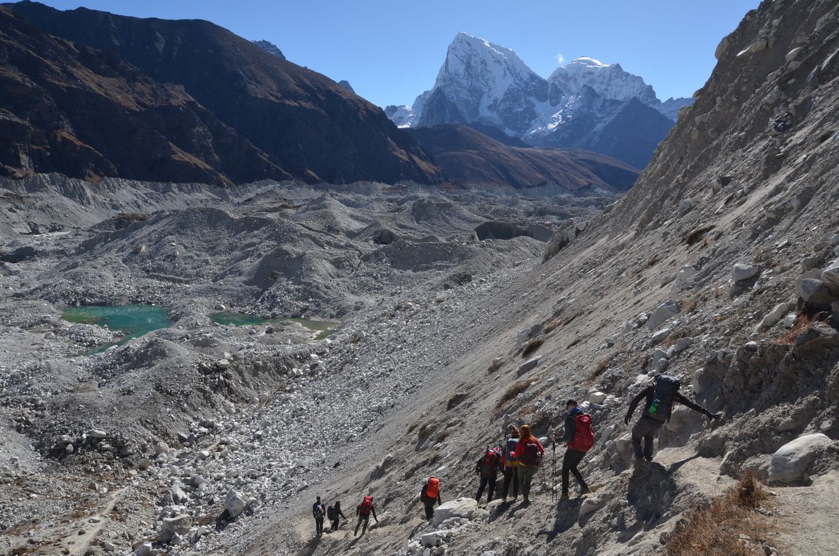
The next morning we started off from Gokyo to cross the Ngojumba glacier that descends from Cho Oyu. Stepping outside of the tea house I caught a whiff from the dining room stove chimney. “Blechh! That’s what’s making me sick!” The smell of burning yak dung.

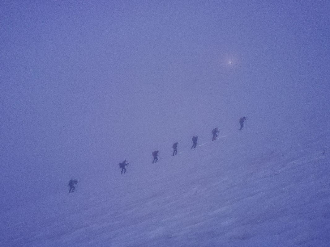
Crossing the glacier, there were lots of small ups and downs, and I was trailing behind the group on both the ups and the downs. It was a short day, but I arrived in Thagnak pretty tired, and was happy to have the afternoon off to chill out and enjoy the new respiratory sickness that was developing.


My cough worsened after dinner, and I was really starting to think about bailing out. The next day was a big one – we would cross the Cho La at 5420m. It had a very steep climb from this side followed by a long descent on a glacier.
A Tough Decision
In conversation with Rolfe we discussed some of the possibilities, and having been here before, I knew what lay before me. It would hurt going over the pass. A lot. I could be slow, no prob for the group since we had lots of time. We had oxygen with us. A guide would carry my day pack. After the pass we would drop down to Dzongla at 4835m and then it was an easy day the next day to Lobuche where I could drop out for a day or two, if needed, while the group moved to Everest base camp and back. If necessary, from Lobuche it was an “easy” evacuation by foot down the Khumbu Valley.
It was a difficult decision to make. Either way. On the negative side was the possibility of getting really sick and perhaps needing a helicopter evacuation and then being dragged into a hospital. Or, at best if I remained sick, trudging along and not realizing any of the goals I had come for as I did in the spring. I had an inclination, particularly in light of that springtime experience, to bail out now. Fighting this was my desire to go on and finish what I was here to do, along with Rolfe’s fathomless optimism (one fathom = six feet, or about 1.83m) and alternate plans to make it work. And dropping out was not all that easy – I would have to walk down for two days to Namche (where there is a medical clinic), then one more day down to Lukla, then fly to Ramechhap and bus back to Kathmandu.
I think I woke Rolfe up three times in the night with different plan B’s, C’s, and D’s. Ultimately, at about 2:30 in the morning I was awake with a cough spitting up green stuff. I called my travel insurance company in the US to see what my options were, and to put them on notice that I was going to leave the group the next day and start to descend.
Walking Out
One of our guides, Asin, accompanied me down, and he carried my duffel and day pack, and kept an eye on me. Fortunately, we didn’t need to recross the glacier to Gokyo – we skirted down below the end of the glacier on a shortcut to Machermo and to Dhole where we had lunch. (They make some pretty good soups in the region.) I was convinced to continue on for “an hour” (really two) to Phortse Tenga (3680m) , and I’m not sure whether or not I regret it. I was ready to spend the night in Dhole, and this section has the most ups and downs. But we did get it out of the way and spent the night 500m lower than Dhole. The tea house at Phortse Tenga kept the WOODstove (See “Dung Lung” below) going all night so the inn was warm. There were still some long climbs to Namche to surmount the next day.

I got into the Mountain Clinic at Namche at about 1PM. The doctor had a good look at me and confirmed what I knew – respiratory tract infection – but she added to the diagnosis a mild case of HAPE (High Altitude Pulmonary Edema). She gave me a half-dozen medications including a five day course of Amoxycillin, decongestant, expectorant, cough syrup, vitamin C …

On the third day to Lukla my butt was really dragging. At one point I shook myself out of a stupor and realized I was trudging along slowly dragging the tip of my walking pole. I can’t imaging what Asin was thinking.
I felt like I was making progress when we finally started ascending Horse-Shit Hill – the place where the trail carpeting provided by pack animals changes from yak to equine. This marks the border where we were leaving Sagarmatha National Park. Not quite to Lukla, but a sign we were getting close. The path rolls up and down and then there’s one very long climb ’til you see the gate announcing your arrival in Lukla. A nice hot shower improved my demeanor.
A few of the trekkers who were taking a helicopter ride to Lukla after walking to Everest base camp arrived the morning after I arrived, and we all got on a morning flight to Ramechhap and then bussed back to Kathmandu. I hung around town for a couple of days since my climbing gear would be coming down with more trekkers later. Before heading to the airport to begin the 24 hour trip home, I popped a couple of lomotils, just to be on the safe side.
Dung Lung
I was still coughing up the last of the Nepal phlegm two weeks after getting home, and I’ve been thinking about the illnesses from the two trips I’ve made to the Khumbu region this year.
Everyone who comes to the Khumbu develops what is called “Khumbu Cough”. It is generally attributed to breathing cold, dry air. And though I have developed a dry cough at altitude before, this is different. It’s a deeper cough. And it hangs on for awhile after returning to warmer, more humid climes.
Many of the symptoms for me this spring and fall were common, starting with loss of appetite. So, loss of appetite, general weakness, shortness of breath (though my %SpO2 was 92% at Dohle and Gokyo) which in the fall then developed into a full blown lung infection. In the spring I did not develop the infection, but I did need to breathe from an O2 bottle descending from Island Peak base camp – I was so short of breath that I couldn’t speak. But Rolfe, thinking it was AMS, asked if I felt better immediately after my first breaths of O2. I did not.
So I’ve been thinking yak dung – breathing the dust and breathing the combustion products. My “realization” as I smelled the fumes leaving Gokyo sparked this. And then I found this paper, Dung Lung: Reactive Airway Disease Syndrome From Yak-Dung Biomass Fuel Smoke. A trekker in the Khumbu is described who was exposed to a high dose of dung stove fumes from a leaky stove overnight in a tea house. He experienced a quicker, more severe onset than me, but the same kinds of symptoms, and notably his %SpO2 was good at 89% at 4300m.
My conclusion is that inhaling yak dung either being burnt or perhaps breathing the dust from the trail causes the Khumbu cough. And I must be more susceptible to it than most, so it develops into a more severe respiratory reaction which then may lead to an infection. The onset came sooner in the fall than in the spring (in the spring the first symptoms started the day after crossing the Cho La. In the fall they started in Namche (though there might be some confusion with food poisoning…)). The sooner onset in the fall may be due to sensitivity from having experienced the condition in the spring.
I had no problems in India in September – no yaks. In 2022 I did a 28 day trek in the Upper Dolpo of Nepal crossing five 5000m passes and had no issues – there were no yaks. In 2019 I trekked for 26 days in Pakistan to K2 base camp and had no issues – no yaks.
I’ll be above 6000m/19,700ft/3280ftm in Ecuador and Chile in January and there won’t be yaks, so I’ll see how it goes.
It might be interesting to try an experiment back in the Khumbu. I could try wearing a particulate mask I have for when I was living in China (though I’m not sure I could trek with it). And/or a “cure” the authors of the paper tried was using an albuterol inhaler which seemed to provide near instant relief to the subject of the paper.
But I don’t think I’ll be the guinea pig…. I need time to forget.
It’s a Small World, Part II
The Kathmandu Guest House is an institution in Nepal. Everyone who’s anyone has stayed there. (I don’t think Elvis was ever there, but the Beatles were.) It’s smack dab in the middle of the Thamel section of town with it’s bustling, noisy, narrow medieval street layout lined with shops selling tat to tourists walking amid the swerving motorbikes. The KGH offers a respite from the hubub. A former princely palace, it’s a multi-building affair built around a garden where travelers congregate for food and drinks and watch trekkers and climbers with their massive amounts of gear come and go.
On the breakfast terrace one morning I kept looking at this woman who looked familiar. I finally went up to her and said, “Are you Valerie?” She was. We met on the trek in Pakistan in 2019. We caught up over lunch and I think I’ve piqued her interest in the trip to Africa…

Oh, did I mention Africa?
African Safari
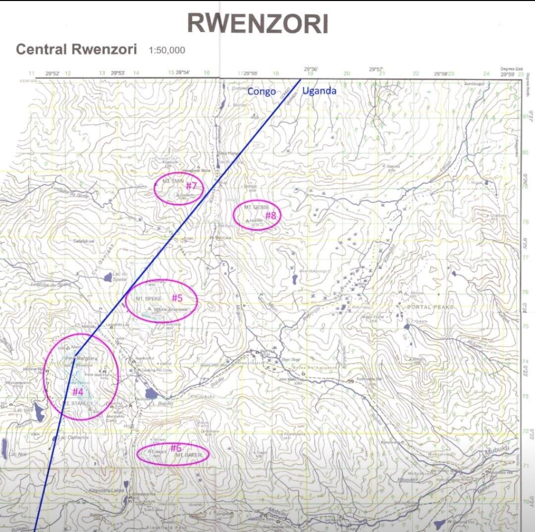
As you may know, Africa is a continent. As such, it has a high point (Mt. Kilimanjaro) and also has a 7th highest point. As I’ve been able to discern, this is Mt. Emin which is located in the Rwenzori mountains which straddle the border of Uganda and the Democratic Republic of Congo. Margherita peak which is right on the border is the 4th highest point on the continent, and Emin is just over the border in the DRC.
Chatting with Rolfe in India about nabbing this 7th summit, it turns out that he has another client he is putting a bespoke trip together for in the Rwenzoris in March ’24. He contacted Bill who had no problem with my joining his trip, and the rest may be history. The details are still being worked out.
But First, an Unfinished Project to Attend to
Remember the end of 2022? The basis of eCard#103 – “Fiasco in South America”? I had done an acclimatization trek in the Atacama desert followed by a climb of Volcan Licancabur (5900m) in Chile to prep me for climbing Ojos del Salado (6890m) and Llullaillaco (at 6740m the inspiration for the “7 7ths at 70”). I got Covid on day 1 and had to quarantine for a week and missed the entire trip…. and then got sick again a few weeks later in Ecuador while prepping to climb Chimborazo (6260m).
Well, I’m going back. This time in reverse order, starting in Ecuador after Christmas and then moving on to Chile for Llullaillaco, Ojos and maybe Aconcagua in Argentina.
Stay tuned.
One Last Bit of Humor
I’ve flown through Doha, Qatar several times now. When departing you always seem to go out through a jetway to a plane parked next to the terminal. But when arriving the routine is to park the plane out on the tarmac and be bussed to the terminal. I’ve always felt we were going in circles on the bus, so this last time I recorded our GPS track. My plane was parked at the upper left of the blue track and the bus deposited us at the lower right.


Yow, you really do have some adventures. How about 7 zoos at 70 to visit, or 7 new countries at 70? This altitude thing is only going to worse as you get older. Of course bad food will happen anywhere.
Jim
I just need to avoid the yak dung….