A Ferry Flight
This isn’t a daredevil exploit, but merely a description of a trip ferrying a Piper Warrior (N138DC – November One Three Eight Delta Charlie) from Farmingdale, NY (Republic Field – KFRG) to Ellensburg, WA (Bowers Field – KELN). There’s a short glossary for non-pilots at the end as it seemed too cumbersome to add explanations in the text.
THE PLAN, Part 1
Planning for this trip began about a week before the actual departure – looking at routes, weather forecasts covering the subsequent week (looking for a good window to depart), and potential fuel and lodging stops. Although I have 1500+ hours in Cherokees, I wouldn’t have the chance to meet “Delta Charlie”, or fly her before I went to pick her up. So even though she had a WAAS enabled GPS with current database, I would fly VFR-only and would always get flight following from ATC. (As we shall see, “always” did not always translate to always.)
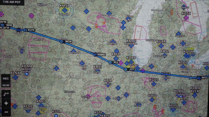
The “plan” was thought out with the idea that it was unlikely to be carried out as planned and would be changed – most likely due to weather. The direct route from KFRG to KELN is 2047nm. Looking at that route, it would take me through Ontario and over the Great Lakes. Some rules and caution entered here.
RULES: 1) A US-registered aircraft cannot enter Canadian airspace with a temporary registration certificate. 2) I wasn’t sure if the plane had an FCC radiotelephone station license (required for international travel, but not within the US). Either way, the temporary registration made Canadian airspace a no-go.
CAUTION: The idea of flying an airplane I hadn’t even seen yet over a large body of water was not appealing.
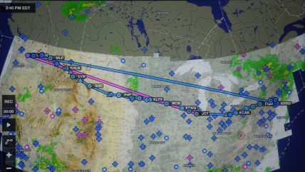
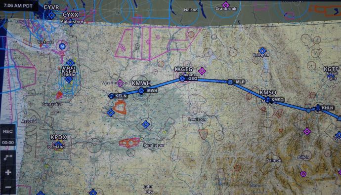
- Smooth blue line is direct route over Canada and the Great Lakes. Magenta line is direct route from Chicago. Segmented blue line is actual flight path.
The rules and caution prompted me to modify my proposed route to the south, more or less directly to Chicago before turning to the northwest. This increased the distance by a couple of hundred miles – estimated now at 2200nm.
THE PLAN, Part 2
In a Warrior flying at 100 knots true airspeed (perhaps not overly ambitious), 2200nm translates to 22 hours of flying with no stops and no wind. Adding 15% to guesstimate stops and wind, makes it 25 hours of flying. With a useable fuel capacity of 48 gallons, conservatively burning 8 gph with an hour reserve means the plane can go for 5 hours between fuel stops – though my bladder cannot. So I figured I’d fly roughly 3 to 4 hour legs with extra urgent stops as needed. All this translates to six, four hour-ish legs. The initial plan was to do two legs per day and if I fueled the plane to the brim at each stop I would always have ample reserves.
I used AOPA’s flight planning web page to lay out the plan and massage it to fit. Their planner has a provision to check fuel prices along the route and to query what services are available at airports along the way. Though fuel was often cheaper at smaller airports, I figured services would be less available, so I decided to aim for overnight stops at Class D or C airports which would have more generous operating hours.
Once the lines were drawn, I printed out the navigation logs that AOPA’s software generates for use during the flight.
Legs 1&2: From Republic Field (KFRG – Farmingdale, NY) to Porter Co. Regional (KVPZ – Valparaiso, IN) with a fuel stop in Clarion, PA (KAXQ). Total time 6:47
Legs 3&4: From KVPZ to Rapid City, SD (KRAP) (gotta love that identifier) with a fuel stop at Quentin Aanenson Field (KLYV – Luverne,MN). This was chosen because fuel was just $3.83 (!!). Total estimated time 7:33
Leg 5: From KRAP to Helena, MT (KHLN) with no planned fuel stop. Estimated time 3:51.
Leg 6: From KHLN to Ellensburg, WA (KELN) final destination with no planned fuel stop. Estimated time 3:34.
The total estimated time that AOPA came up with was 21:45, which did not include time for taxi, takeoff & climb, and approach to land, or wind. The reality, as expected, was slightly different as you can see in the daily summary charts.
DAY ONE – MEETING N138DC
Arriving at KFRG, “Delta Charlie” was ready to go. She was a 2001 Piper Warrior with 5000 hours on the airframe and 1000 hours on the current engine. She looked to be in pretty good shape, and the logbooks looked clean and up to date. After a bit of consternation I found the temporary registration and airworthiness certificate so all the paperwork was in order. Her instrument panel only had one communications radio and no other navigation capability than the GPS – no redundancy. So it would be strictly a VFR adventure.
A very thorough pre-flight inspection turned up some suspicious green-ish stuff coming out of the gascolator that smelled like oil mixed in with the gas. The next sample looked like clean 100LL avgas. This would be checked repeatedly enroute and was never an issue. She started easily with just a short squirt of prime. Otherwise there was nothing of concern noted. I did a complete run-up three times in the course of taxiing to the end of the very busy runway at Republic.
DAY ONE – OFF WE GO!
There was a big TFR around the NY area (perhaps some Russians were visiting Trump Tower?), but it wasn’t significantly different than the boundaries of the Class B airspace that exists there. So, I took off and headed north to the Carmel (CMK) VOR to avoid it all before heading due west toward Clarion.
Getting up above the scattered clouds at 6500 feet made it a pretty smooth ride. From CMK I flew to Williamsport (FQM) VOR and directly to Clarion for my first planned fuel stop and found the first hiccup in the plane’s systems. When cancelling flight following going in to land at Clarion and told to “squawk VFR” I pushed the “VFR” button on the Garmin transponder to transmit “1200” and nothing happened. No sweat. Just punch in “1200”. Well, that would have been a solution, but the “2” button didn’t work. Consternation. More, harder, frantic button pushing ensued. Eventually it worked and cleared itself up during the course of the trip.
I had started a bit late today, but I figured the length of the July day would allow me to make it to my proposed first night at Valparaiso, IN (KVPZ).
Not to be.
Findlay, OH (KFDY) was my “planned alternate” in case I couldn’t make it to KVPZ. I had flight following, talking to the Mansfield departure controller. About 30 miles from Findlay I was about to query her about the storm I saw building ahead of me when she called to warn me of the now extreme precipitation which was just moving over Findlay and there was no real way around it. So, I had my first diversion. It had been a long day already, so I just elected to turn back and land at Mansfield (KMFD) for the night.
The friendly FBO (Richland Aviation) was open and gave me overnight use of their courtesy car. Town was basically dead on Sunday evening, but the Holiday Inn welcomed me, and I found a TGIF.
Day 1: Farmingdale to Clarion (fuel) to Mansfield.
DAY TWO
The morning dawned solid IFR. I had to wait until about 10:30 before things cleared up enough to depart. It was unclear how clear it was, so I planned to just move on to KVPZ and check the weather again. Once I was airborne at 2500 feet it seemed improvement was in the wind. I climbed up to 4500 feet to have a better look and it looked pretty good indeed. So I advised ATC that my new destination was now Dubuque, IA (KDBQ). There were a few more clouds that pushed me up to 6500 feet, but I really preferred to be higher as I neared Chicago, anyway. And as soon as I got up that high I could see it was severe clear to the west.
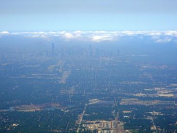
Chicago in the haze
Flying direct to the Joliet (JOT) VOR would keep me south of Chicago’s airspace, but it was still a pretty busy place to be. A friend had loaned me a Stratus box which would receive and display traffic advisories on my iPad. The WAAS GPS also offered traffic advisories, and I was getting advisories from ATC. Interestingly, there was still traffic out there that NONE of these aids warned me of.
MORAL OF THE STORY: Look outside. I’ve experienced the same thing many times around Boston. It really is important to not rely on the gadgets.
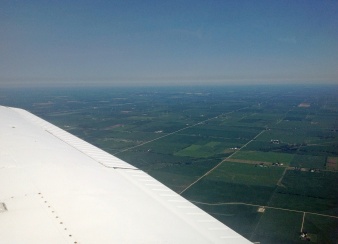
West of Chicago
Chicago behind me, the skies were much less busy. In case you didn’t know it, it’s flat out there. Dubuque (KDBQ) was just a couple of hours down the road. I wasn’t too overly concerned about finding cheap fuel, but I figured I’d go for it if it was convenient. KDBQ was advertising $4.06 and it was on the way. Imagine my surprise when I discovered their advertised fuel price was exclusive of the tax ….. The net cost was $4.58! (At least it wasn’t $7.00).
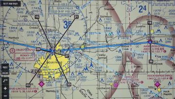
Orwellian tower east of KFSD. Top is at 3445′ above sea level, 1984′ above the ground.
An hour laze in the FBO, checking the weather and recharging my tablet, I launched with the aim of making it to Sioux Falls, SD (KFSD) for the night. It was extraordinarily flat. Quite a change from New England (where there are no straight roads), all the roads here go N-S or E-W. At one point the clouds were building a bit and it was getting fairly murky, but still VFR. ATC dropped me out over the corn fields somewhere, so I flew without them into Luverne, MN (KLYV) for a cheap fill-up ($3.83) before the short hop into KFSD. Well off my route, but just southeast of KFSD is an Orwellian tower – 1984 feet tall. It looked pretty enormous in the evening haze.
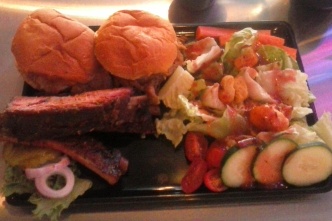
BBQ in Sioux Falls
KFSD is a busy Class D field. I did a tight pattern and landed short to get off the runway at the FBO at the north end of the main runway. Maverick Aviation is a fabulous FBO. No tie down fee, no landing fee, no minimum fuel purchase, great lounge, awesome vending machines, good coffee. Nirvana in South Dakota! They arranged a hotel for me and off I went to explore the sights and sounds of Sioux Falls. There actually are falls.
Oh, and barbecue. Pretty good barbecue.
Not really a “problem”, but one of the problems of traveling in a light plane is that you’re always checking the weather. It’s constant. After you land you no sooner than get the plane tied down and you’re thinking about what’s coming the next day. You check after dinner, and before you go to bed. It’s the first thing you do in the morning. Then check at breakfast. Checking again when you get to the airport.
Day 2: Mansfield to Dubuque (fuel) to Luverne, MN (fuel) to Sioux Falls
DAY THREE
The modified plan for Day 3 was to get all the way to Helena, MT (KHLN). There were convective SIGMETs in effect northeast of KSFD and north of my western route. Pierre (pronounced Peer) north and west of my route had advisories out. So I launched with the thought that I’d be looking for a place to land anywhere enroute and run away when appropriate. All that flat terrain is comforting when you’re considering the possibilities of not making your destination.
I departed and climbed to 4500 feet and the first hour was uneventful. I could see the dark sky to the NW of me that was the weather over Pierre, but it wasn’t directly in my path. ATC called to advise me there was severe weather at 60 miles at my 2 o’clock – Pierre. No issue, but something to watch. A layer of scattered clouds was forming around my altitude so I climbed to 6500 feet.
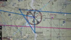
The scattered layer was clumping up to an overcast layer and I climbed to 7500 feet to stay VFR advising ATC of my non-standard altitude and that I was prepared to go higher. It was starting to get murky across my entire field of view. The controller told me the storm was now from my 10 to 3 o’clock. Being the observant lad that I am, I had already noticed this and had been reviewing my chart and my options. I had just passed Chamberlain Field (9V9) and thought that would be a good spot to put down and wait for the storm to pass. (I also knew it was severe clear behind me and I could easily outrun the storm back to the east if I had to.) I advised the controller of my intentions and he said, “That sounds like a good plan.”
Artist’s rendition of running away from a thunderstorm and landing at 9V9.
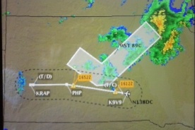
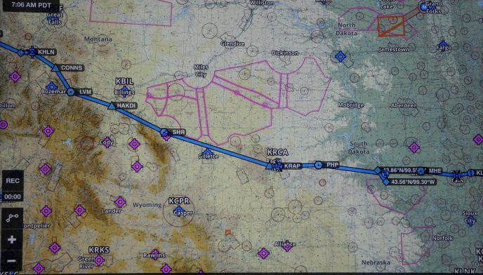
Convective SIGMET north of my route to KRAP
Doing a U-turn to get to 9V9 was OK, the problem was getting below the cloud layer. I headed off toward the edge of the clouds and found a big hole to descend through while tuning in their ASOS. The field was just VFR with a ceiling at 1500 feet but visibility greater than 10 miles. The wind was reported at 350/15G22. The hard runway ran 13/31, so there was going to be a bit of a crosswind on landing, but this was handled without incident. The FBO was a room attached to a guy’s house, but there was a comfy lounge chair. I dipped into my reserve of granola bars and hung out for about an hour while the storm moved past before saddling up to move on.
Upon departure the wind was 050/14G22 – storm passage had shifted the wind to a direct crosswind beyond the demonstrated crosswind capability of a Warrior (which is 17 kts). But I had another option. A grass runway pointing 18/36. Taking off 36 reduced the crosswind component to 11G17 – right on the limit. The grass was a bit long and the plane slow to accelerate, but I got up in ground effect well before the mid-point of the runway, corrected for the crosswind and was on my way.
It was beautiful. I had views of the Badlands to the south as I approached Rapid City
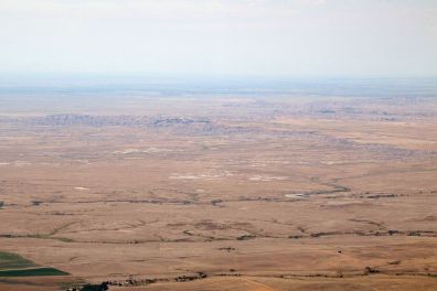
The Badlands
(KRAP) on the eastern edge of the Black Hills. It was really hard to make out the airport, but I finally figured out where it was, entered the traffic pattern and made my landing. Rolling up to the self-serve pump, a younger pilot in a Cessna pulled up behind me. He turned out to be a commercial student pilot from Denver doing his long cross country solo. After refueling I stopped in the FBO and chatted with a couple traveling around the west in a Commanche and now heading east toward the weather I left behind. We exchanged pointers from the road that we had acquired. (It was an early joke when GPS first came out that when ATC asked your position, you could tell them you are something like 1279 nm east of Peoria…. I heard ATC instruct the Commanche pilot to report 210nm west of Sioux Falls…)
The field elevation at KRAP is published at 3204 ft. Preparing to depart I tuned in the ASOS. It was a warm day and the ASOS was reporting a density altitude of 6200 ft. Those of us who live close to sea level normally takeoff with the mixture full rich. Under these circumstances I leaned the engine for best power during the run-up and took off with that mixture setting.
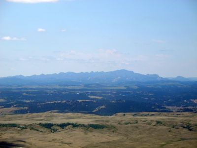
The Black Hills from the east.
During pre-flight planning, I had looked at the Black Hills on the chart and pondered going around them since I didn’t know what the winds might do and how quickly I could climb over them in what I assumed would be high density altitude.
Ultimately, I took off and turned directly on course in the climb. I climbed to 8500 feet to give ample margin over anything in the area. I requested flight following from the tower and they handed me off to Ellsworth (AFB) departure control who informed me that Denver Center would not be able to see me on radar at that altitude once they handed me off. So I climbed up to 10,500 feet also hoping to find smoother air. Eventually I fell off the radar, anyway, and was picked up later in the day by Salt Lake Center.
It was smoother, for a while. It turned out to be a bumpy afternoon. I had planned a winding route through the passes from Bozeman to Helena, but now that I was up so high this wasn’t necessary, and I re-plotted a more direct route to Helena to save a little time.
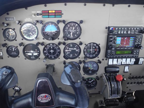
Somewhere. You don’t usually get to see a Warrior’s altimeter reading 10,500 feet. At this particular moment, my indicated airspeed is about 92kts and ground speed (on the GPS) is 94.6kts. We’re pointing west. I’m not talking to ATC since the transponder is set to 1200.
The winds were keeping me busy. At one moment I’d get the plane trimmed out with about 95 kts indicated and 109 across the ground and a few minutes later I’d have the nose up to 79 (Vy) with extra power in order to maintain altitude while my ground speed was at 80. It was mountain wave activity or thermals or wind shear that shifted back and forth every few minutes for a couple of hours. I kept looking at the hills to my left/west trying to conceive how the local topography could be doing this, but knowing that mountain waves can extend for great distances from their source I might not have been able to see the offending hills. The country below me was a uniform color, so I couldn’t convince myself that it was pockets of thermals – though it was warm below. The air was so dry (I theorized) that there weren’t any clouds forming due to thermals. Regardless of the cause, the wind shear or up and down drafts were right on the edge of the Warriors ability to maintain altitude. I just resigned myself to slower progress and kept an eye on my fuel consumption. My diversion earlier in the day cost me a bit of fuel, and the wind was taking it’s toll, but I still had oodles, and there were many options along the way.
No radar contact coming into Helena, so approach/departure control uses position reporting to separate traffic – my first report was at 30 miles to the east. Helena is a nice spot nestled among hills to the north, west and south and a nice lake to the east. The field has a Beck’s U-Pump for fueling. Next to the pumps is a small place called Mickey’s – it’s a small FBO with a full kitchen and a bunk room where you can stay for free. Never seen anything like that at an airport before. I couldn’t find a hotel that had a shuttle service, so I ended up staying at The Carolina B&B (highly recommended) in the historic district of town across the street from the original governor’s mansion. The proprietress picked me up and recommended a great restaurant a short walk from the B&B. Nice town.
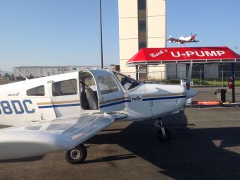
N138DC on the ramp at Helena
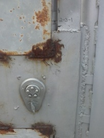
High security at Helena. You’d never guess the combination.
Day 3: Sioux Falls to Chamberlain (storm) to Rapid City (fuel) to Helena.
DAY FOUR
The morning started off lazily enough in the B&B’s garden. An all-too yummy and plentiful breakfast (need to check weight and balance calculations) and a slow motion start began the last leg of this adventure. I departed slightly to the southwest to take advantage of the lower terrain heading toward MacDonald Pass as I climbed in the cool air of the morning. Helena is at 3877 feet and it took about 27 miles and 20 minutes to get up to 10,500 feet at 85 kts. Departure control advised me that Salt Lake Center would neither see nor hear me at 10,500 feet until I got past Missoula, so I settled into a nice smooth, quiet flight in contrast to the day before. There were TFR’s for forest fires south and north of my route which I had a front seat for. I had hoped to catch sight of a tanker working, but only heard them on the air and never saw them. The skies were pretty hazy all over the west – it has been dry and the fires plentiful.
TFRs (the red areas) for forest fires west of Helena along my route
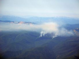
Forest Fire
I picked up flight following west of Missoula, cleared the mountains of Montana and Idaho (caught a view of Coeur d’Alene to the north) and arrived over the plain of central and western Washington at Spokane. Seattle Center asked me if I wanted to descend.
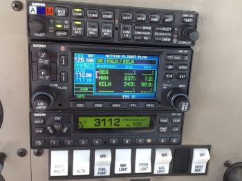
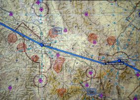
58 miles from KELN. The transponder is the lower box – I’m squawking 3112 for ATC to track me. The altitude I’m reporting to them is 10500. 126.100 is the frequency for Seattle Center.
“No. It took a long time to get up here, I’d like to enjoy the view.” So I stayed at 10,500 until 30 miles from Ellensburg. It was hazy. As I got closer I noticed something sticking up in the haze directly on my route. It turned out to be Mt. Rainier which was a pretty nice sight.
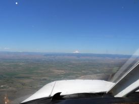
Mt. Rainier growing out of the horizon.
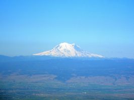
Rainier with Ellensburg in foreground.
Arriving at Ellensburg was uneventful except for the fact that after I taxied to the ramp and shut down, I couldn’t get the door open. I had to stick my arm out the pilot’s side vent window and flag a mechanic down in one of the hangars to help me get out. I really had hoped to get out of the plane at this point.
IN THE END
The total flight time was 25.6 hours to cover 2273 nm, which, surprisingly, was pretty close to my initial guesstimate of 25 hours. The flight time for each of the four days were 5.7, 7.5, 8.2 and 4.2 hours. I figure I burned 193.7 gallons for an overall burn rate of 7.6 gph. (Though on the 4.6 hour turbulent leg from KRAP to KHLN I burned 8.2gph.) It would have been more economical had the plane been equipped with an EGT, but I had to revert to the crude method of leaning to engine roughness and then enriching by sound/tach.
In the end, that’s a lot of time in a Warrior.
Day 4: Helena to Ellensburg
Glossary
AOPA – Aircraft Owner’s and Pilots Association – The largest pilot organization in the US. They have oodles of free information online as well as flight planning software and weather tools.
ATC – Air Traffic Control. The folks who provide the service to keep air traffic moving smoothly. From control towers at airfields, to “approach” controllers who manage traffic arriving and departing from airports, to “center” controllers who manage enroute traffic. They may or may not have radar capability.
ATIS/ASOS/AWOS – a recorded, sometimes automatically generated weather broadcast usually only reporting local conditions. The wind may be reported as 050/11G17 which means it’s blowing from the northeast (50 degress) at 11 kts gusting to 17 kts.
B&B – Benedictine & Brandy, or Bed & Breakfast depending on your preference.
Class B, C, D Airspace – Airspace carved out around airports that partitions the space to allow multiple controllers to handle traffic and manage flow. Class B is the largest and busiest (think Boston, New York, etc.) and restricts VFR traffic. Class D is much smaller only having a control tower.
Density Altitude – When the air is warm or humid, it’s density decreases. When air is less dense, it is all disadvantageous to flying – the engine generates less power, the propeller generates less thrust, and the wing generates less lift. Flying from high altitude airports by definition means you are at a higher “density altitude” and will have worse performance. At low altitudes, when the conditions are right, it “feels” just like being at a high altitude. A calculated density altitude based on barometric pressure, temperature and humidity equates the condition to higher elevation. Performance charts for the airplane tell you the bad news. Longer takeoff roll, poorer climb performance.
FBO – Fixed Base Operator. Where you park, get fuel, find a lounge, restrooms, ground services. Some have no charges. Some are exorbitant.
Flight Following – A service provided by ATC to provide traffic advisories to VFR traffic on a workload permitting basis. VFR pilots are still responsible to “see and avoid”.
KFRG, etc. – a four letter airport identifier. Everyone worldwide uses a three letter identifier and then sticks a letter on the front for the country (in the US, we use “K”. Canada uses a “C”. Just to show there is logic to this, Angola uses an “F”). If the identifier begins with a number (e.g. 9V9) the “K” is usually not used since these are usually dinky little airports.
nm/kts – Nautical Mile/knots – At 6076 feet it is about 15% longer than a statute mile at 5280 feet. (It is derived from one minute, a sixtieth of a degree, of latitude – thank the Babylonians.) A knot is a nautical mile per hour. 100 kts is about 115 mph.
Piper Warrior – A four seat airplane in the Piper Cherokee family. It typically has a 160 horsepower engine and doesn’t go very fast.
Run-up – Performed on the ground as part of the pre-flight checks. The engine is powered up to 60% power, or so, and the dual ignition systems are verified along with oil temp and pressure, fuel pressure and the vacuum system. No blinking red lights allowed.
Runway headings – Published as 02 or 36, for instance. Just add a zero to the end and you get the magnetic heading of the runway. And you can generally land in either direction on a runway, so they will be designated 18/36 or 02/20.
SIGMET – An inflight weather advisory (SIGnificant METeorological information) of something bad going on in the atmosphere. A SIGMET can be issued for “convective activity” (read: thunderstorms), or specifically for tornadoes, volcanic ash, severe icing, etc. A “Convective SIGMET” is an invitation to stay away.
TFR – Temporary Flight Restriction. These can pop up for multiple reasons – VIP travel, natural disasters (fires, hurricane damage/rescue), NASCAR races, football games. They are intended to keep traffic out that is not concerned with the event.
Transponder – A box in the plane that transmits altitude and a code to ATC. The code is displayed on ATC radar screens. “1200” is the normal code for VFR traffic buzzing around aimlessly. When you request and get flight following you are issued a discrete code to “squawk” (transmit), e.g. “3114” so that ATC can identify you quickly.
VFR – Visual Flight Rules. You fly by looking outside, visually. You use navigation aids (radios, GPS) to assist, but you are ultimately responsible to “see and avoid” other aircraft. Under IFR (Instrument Flight Rules) you can’t see nothin’ and fly by reference to your instruments only.
VOR – A VHF radio navigation aid identified by three letters, e.g. JOT is the Joliet VOR.
Vy – The indicated airspeed that gives the best rate of climb for a airplane.
WAAS – Wide Area Augmentation System are ground based radio signals that supplement GPS information to make it even more accurate.
100LL Avgas – In the aviation world, we still use leaded gas. It is “low lead”, but lead nonetheless. Avgas is usually 100 octane.

Hi Rick, I’m Barbara, Peter Simpson’s wife. I was born in Klerksdorp, South Africa. My dad owned a Piper Cub with his friend, Garni. He used to take me up squashed between himself and Garni, and I (about 10 years old) braved it out as we scarily somersaulted and swooped…On return, my relieved mother clutched me, crying, ‘the child is green, Joe!’ Your flight brought back the excitement of those adventures. My dad took some 33mm film over the game reserves and Victoria Falls (now on DVD). How come you were ferrying the Piper Warrior?
I’m an instructor for a flight school. A school in Washington who bought one of our customer’s planes also bought this plane in NY. They twisted my arm to fly it west. Best to you and Peter!
I went with a CFII friend on a ferry flight from Dayton, OH to Phoenix, AZ in an SR22 over the winter… obviously a much faster crossing the country in one of those than in an a PA28. I am a Piper Warrior pilot myself. Your trip sounds right up my alley. It was fun crossing the country in the Cirrus, but I’d love to do a slower hop with more stops. Seems like it would be such a wonderful experience.
Anyway, great write up. Thank you for sharing!
Thanks and you’re welcome. Sometimes there is something to be said for speed 🙂